


Gouille des Fours

arno55v
User
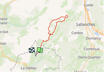

Length
28 km

Max alt
2142 m

Uphill gradient
1583 m
Km-Effort
49 km

Min alt
1371 m

Downhill gradient
1582 m
Boucle
Yes
Creation date :
2014-12-10 00:00:00.0
Updated on :
2014-12-10 00:00:00.0
10h02
Difficulty : Medium

FREE GPS app for hiking
 SityTrail
IGN / Geographical institutes
SityTrail Plus
The world is yours!
About
Trail Walking of 28 km to be discovered at Auvergne-Rhône-Alpes, Savoy, La Giettaz. This trail is proposed by arno55v.
Description
bivouac à la gouille des fours
Positioning
Country:
France
Region :
Auvergne-Rhône-Alpes
Department/Province :
Savoy
Municipality :
La Giettaz
Location:
Unknown
Start:(Dec)
Start:(UTM)
306947 ; 5083987 (32T) N.
Comments